
Jamroli topographic map
Interactive map
Click on the map to display elevation.
About this map
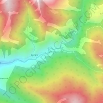
Name: Jamroli topographic map, elevation, terrain.
Location: Jamroli, Ghansali, Tehri Garhwal District, Uttarakhand, India (30.58064 78.69777 30.62064 78.73777)
Average elevation: 7,021 ft
Minimum elevation: 5,246 ft
Maximum elevation: 9,032 ft
Other topographic maps
Click on a map to view its topography, its elevation and its terrain.
pilkhi
India > Uttarakhand > Ghansali
pilkhi, Ghansali, Tehri Garhwal, Uttarakhand, 249181, India
Average elevation: 3,793 ft
Ghansali
India > Uttarakhand > Ghansali
Ghansali, Tehri Garhwal, Uttarakhand, India
Average elevation: 3,645 ft