
Make a donation
Gear up for your next adventure:
As an Amazon Associate, this site earns from qualifying purchases at no extra cost to you.
WaKeeney topographic map
Click on the map to display elevation.
Make a donation
Gear up for your next adventure:
As an Amazon Associate, this site earns from qualifying purchases at no extra cost to you.
WaKeeney
WaKeeney is located at 39°01′28″N 99°52′55″W / 39.024467°N 99.881972°W / 39.024467; -99.881972 (39.024467, -99.881972) at an elevation of 2,447 feet (746 m). Located in northwestern Kansas at the intersection of Interstate 70 and U.S. Route 283, it is 162 miles (261 km) northwest of Wichita, 281 miles (452 km) east-southeast of Denver, and 284 miles (457 km) west of Kansas City.
Make a donation
Gear up for your next adventure:
As an Amazon Associate, this site earns from qualifying purchases at no extra cost to you.
About this map
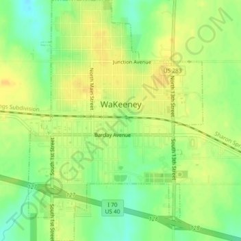
Name: WaKeeney topographic map, elevation, terrain.
Location: WaKeeney, Trego County, Kansas, 67672, United States (39.00872 -99.89375 39.03735 -99.86702)
Average elevation: 2,451 ft
Minimum elevation: 2,398 ft
Maximum elevation: 2,480 ft
Trego County trails, hiking, mountain biking, running and outdoor activities
Make a donation
Gear up for your next adventure:
As an Amazon Associate, this site earns from qualifying purchases at no extra cost to you.