Geolocate

Zinga topographic map

Click on the map to display elevation.

About this map

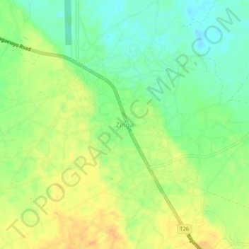
Name: Zinga topographic map, elevation, terrain.

Location: Zinga, Bagamoyo, Pwani Region, Coastal Zone, Tanzania (-6.55167 38.96681 -6.51167 39.00681)

Average elevation: 98 ft

Minimum elevation: 46 ft

Maximum elevation: 144 ft

Other topographic maps

Click on a map to view its topography, its elevation and its terrain.

Mkuranga

Tanzania > Pwani Region

Average elevation: 292 ft

Kisarawe

Tanzania > Pwani Region

Average elevation: 443 ft

Mkuranga

Tanzania > Pwani Region

Average elevation: 292 ft

Rufiji

Tanzania > Pwani Region

Average elevation: 180 ft

Rufiji

Tanzania > Pwani Region

Average elevation: 577 ft

Mkuranga

Tanzania > Pwani Region

Average elevation: 292 ft

ruvu river

Tanzania > Pwani Region

Average elevation: 338 ft

Mafia Island

Tanzania > Pwani Region

Average elevation: 13 ft

Rufiji

Tanzania > Pwani Region

Average elevation: 577 ft

Gear up for your next adventure:

🧤Hiking Gloves - Protective gloves for rugged trails
🧭Orienteering Set - Complete compass and map reading kit
🔋Rechargeable Batteries - Power up your outdoor devices
🧭Outdoor Navigation Book - Learn advanced navigation skills
🗻Climbing Gear Basics - Essential gear for beginner climbers

As an Amazon Associate, this site earns from qualifying purchases at no extra cost to you.