Geolocate

Tower topographic map

Click on the map to display elevation.

About this map

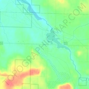
Name: Tower topographic map, elevation, terrain.

Location: Tower, Forest Township, Cheboygan County, Michigan, 49792, United States (45.33529 -84.32057 45.37529 -84.28057)

Average elevation: 761 ft

Minimum elevation: 682 ft

Maximum elevation: 899 ft

Cheboygan County trails, hiking, mountain biking, running and outdoor activities

Other topographic maps

Click on a map to view its topography, its elevation and its terrain.

Grant Township

United States > Michigan > Cheboygan County

Average elevation: 679 ft

Munro Township

United States > Michigan > Cheboygan County

Average elevation: 748 ft

Ellis Township

United States > Michigan > Cheboygan County

Average elevation: 830 ft

Cheboygan

United States > Michigan > Cheboygan County

Average elevation: 594 ft

Indian River

United States > Michigan > Cheboygan County

Average elevation: 643 ft

Gear up for your next adventure:

🪶Fire Starter Kit - Reliable fire starter for survival and camping
📱Solar Portable Charger - Solar power bank for charging devices off‑grid
🛰️Satellite Messengers - Emergency SOS and two-way messaging for off-grid adventures
🥄Camping Utensil Set - Lightweight utensils for outdoor meals
🎒Hydration Pack - Hands‑free water reservoir for long hikes

As an Amazon Associate, this site earns from qualifying purchases at no extra cost to you.