
Province of Ascope topographic map
Interactive map
Click on the map to display elevation.
About this map
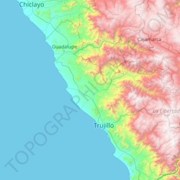
Name: Province of Ascope topographic map, elevation, terrain.
Location: Province of Ascope, La Libertad, Peru (-8.72463 -80.18367 -6.72463 -78.18367)
Average elevation: 3,432 ft
Minimum elevation: 0 ft
Maximum elevation: 14,170 ft
Other topographic maps
Click on a map to view its topography, its elevation and its terrain.
Chepen
Peru > La Libertad > Salpo
Chepen, Salpo, Province of Otuzco, La Libertad, Peru
Average elevation: 11,421 ft
Yaman
Peru > La Libertad > Chugay
Yaman, Chugay, Province of Sánchez Carrión, La Libertad, Peru
Average elevation: 9,029 ft
Asia
Peru > La Libertad > Buldibuyo
Asia, Buldibuyo, Province of Pataz, La Libertad, Peru
Average elevation: 10,098 ft
Huanchaquito
Peru > La Libertad > Huanchaco
Huanchaquito, Huanchaco, Province of Trujillo, La Libertad, 13000, Peru
Average elevation: 39 ft
El Porvenir
Peru > La Libertad > El Porvenir
El Porvenir, Province of Trujillo, La Libertad, Peru
Average elevation: 774 ft
Laredo
Peru > La Libertad > Laredo
Laredo, Province of Trujillo, La Libertad, Peru
Average elevation: 1,388 ft
Trujillo
Trujillo, Province of Trujillo, La Libertad, Peru
Average elevation: 121 ft
El Inca
Peru > La Libertad > Chao > El Inca
El Inca, Chao, Province of Virú, La Libertad, Peru
Average elevation: 433 ft
Santiago de Chuco
Santiago de Chuco, Province of Santiago de Chuco, La Libertad, Peru
Average elevation: 9,708 ft
Province of Pataz
Province of Pataz, La Libertad, 041, Peru
Average elevation: 9,836 ft
La Esperanza
La Esperanza, Province of Trujillo, La Libertad, Peru
Average elevation: 377 ft
Province of Santiago de Chuco
Peru > La Libertad > Santa Cruz de Chuca
Province of Santiago de Chuco, Santa Cruz de Chuca, Santiago de Chuco, La Libertad, Peru
Average elevation: 10,807 ft
San José de Moro
Peru > La Libertad > San José de Moro
San José de Moro, Province of Chepén, La Libertad, Peru
Average elevation: 384 ft