Geolocate

Wanssum topographic map

Click on the map to display elevation.

About this map

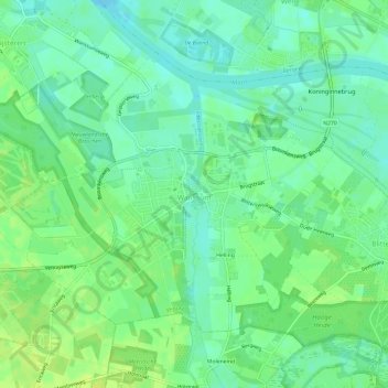
Name: Wanssum topographic map, elevation, terrain.

Location: Wanssum, Venray, Limburg, Netherlands (51.52295 6.04735 51.54924 6.10691)

Average elevation: 59 ft

Minimum elevation: 33 ft

Maximum elevation: 82 ft

Other topographic maps

Click on a map to view its topography, its elevation and its terrain.

Heierhoeven

Netherlands > Limburg > Venlo

Average elevation: 89 ft

Mariapeel

Netherlands > Limburg > Evertsoord

Average elevation: 105 ft

Cottessen

Netherlands > Limburg > Vijlen

Average elevation: 600 ft

Overheek

Netherlands > Limburg > Termaar

Average elevation: 387 ft

Schimmert

Netherlands > Limburg > Schimmert > Schimmert

Average elevation: 410 ft

Hout-Blerick

Netherlands > Limburg > Venlo

Average elevation: 72 ft

Gear up for your next adventure:

👓Polarized Sunglasses - Outdoor sunglasses for glare reduction
🔪Outdoor Multitools - Essential survival tools for gear repair and field use
🩳Quick‑Dry Hiking Shorts - Comfortable and quick‑dry shorts for summer hiking
📡Handheld GPS Device - Reliable handheld GPS for outdoor navigation
🧤Tactile Hiking Gloves - Keep hands warm while operating GPS and smartphone screens

As an Amazon Associate, this site earns from qualifying purchases at no extra cost to you.