
Cansano topographic map
Click on the map to display elevation.
Cansano
Cansano is located 9 km (5.6 mi) from Sulmona, on a hill near the Valle Peligna, at 835 m (2,740 ft) m above sea level. The minimum altitude of the municipality of Cansano is 599 m (1,965 ft), while the maximum is 1,792 m (5,879 ft). The area of the municipal territory is 37.70 km2 (14.56 sq mi).
About this map
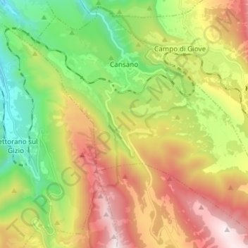
Name: Cansano topographic map, elevation, terrain.
Location: Cansano, L'Aquila, Abruzzo, Italy (41.93964 13.96641 42.02563 14.08808)
Average elevation: 3,658 ft
Minimum elevation: 1,555 ft
Maximum elevation: 6,473 ft
Other topographic maps
Click on a map to view its topography, its elevation and its terrain.
Assergi
Italy > Abruzzo > L'Aquila > L'Aquila
Assergi is a frazione of the comune of L'Aquila, located about 11 km (6.8 mi) from the capital. With a population of just over 500, it is situated at an altitude of approximately 1,000 meters, below the western slope of the Gran Sasso in a small plain called the Piana di Assergi (Plain of Assergi). Assergi was…
Average elevation: 3,396 ft