
Make a donation
Gear up for your next adventure:
As an Amazon Associate, this site earns from qualifying purchases at no extra cost to you.
Santa Vitória topographic map
Click on the map to display elevation.
Make a donation
Gear up for your next adventure:
As an Amazon Associate, this site earns from qualifying purchases at no extra cost to you.
About this map
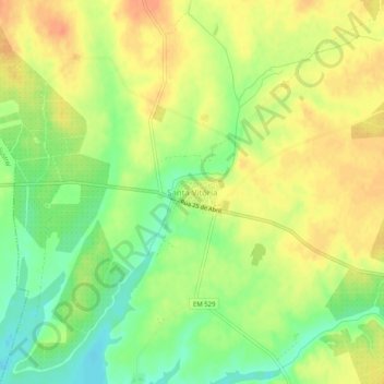
Name: Santa Vitória topographic map, elevation, terrain.
Location: Santa Vitória, Beja, 7800-732, Portugal (37.94663 -8.04652 37.98663 -8.00652)
Average elevation: 492 ft
Minimum elevation: 417 ft
Maximum elevation: 551 ft
Make a donation
Gear up for your next adventure:
As an Amazon Associate, this site earns from qualifying purchases at no extra cost to you.
Other topographic maps
Click on a map to view its topography, its elevation and its terrain.
Cabeça Gorda
A freguesia foi criada com a designação de Nossa Senhora da Conceição da Rocha, embora seja conhecida por Cabeça Gorda. Pensa-se que esta designação popular, certamente muito mais antiga do que a oficial, e que acabou por se generalizar ao ponto daquela ser praticamente desconhecida, teve a sua origem…
Average elevation: 531 ft
Make a donation
Gear up for your next adventure:
As an Amazon Associate, this site earns from qualifying purchases at no extra cost to you.