
Make a donation
Gear up for your next adventure:
As an Amazon Associate, this site earns from qualifying purchases at no extra cost to you.
Reserva Estadual do Morro Grande topographic map
Click on the map to display elevation.
Make a donation
Gear up for your next adventure:
As an Amazon Associate, this site earns from qualifying purchases at no extra cost to you.
About this map
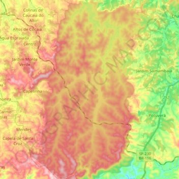
Name: Reserva Estadual do Morro Grande topographic map, elevation, terrain.
Average elevation: 3,002 ft
Minimum elevation: 2,402 ft
Maximum elevation: 3,524 ft
Make a donation
Gear up for your next adventure:
As an Amazon Associate, this site earns from qualifying purchases at no extra cost to you.
Other topographic maps
Click on a map to view its topography, its elevation and its terrain.
Caucaia do Alto
Brasil > São Paulo > Região Metropolitana de São Paulo > Cotia
Average elevation: 3,061 ft
Parque Cemucam
Brasil > São Paulo > Região Metropolitana de São Paulo > Cotia
Average elevation: 2,677 ft
Make a donation
Gear up for your next adventure:
As an Amazon Associate, this site earns from qualifying purchases at no extra cost to you.