
Ujo topographic map
Interactive map
Click on the map to display elevation.
About this map
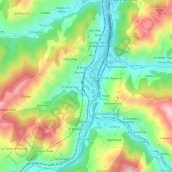
Name: Ujo topographic map, elevation, terrain.
Location: Ujo, Mieres, Asturias, 33640, España (43.18509 -5.81132 43.22509 -5.77132)
Average elevation: 1,273 ft
Minimum elevation: 709 ft
Maximum elevation: 2,149 ft
Other topographic maps
Click on a map to view its topography, its elevation and its terrain.
Castriḷḷón
España > Asturias > Mieres > Turón
Castriḷḷón, Turón, Mieres, Asturias, 33610, España
Average elevation: 1,791 ft
El Ribayón
España > Asturias > Mieres > Ujo
El Ribayón, Ujo, Mieres, Asturias, 33640, España
Average elevation: 1,280 ft
El Carrilón (La Rebollá)
España > Asturias > Mieres > Ablaña de Arriba
El Carrilón (La Rebollá), Ablaña de Arriba, Mieres, Asturias, 33650, España
Average elevation: 1,155 ft