
Pine Island topographic map
Click on the map to display elevation.
About this map
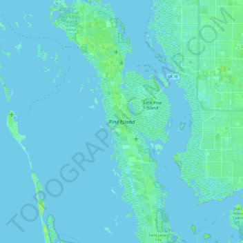
Name: Pine Island topographic map, elevation, terrain.
Average elevation: 3 ft
Minimum elevation: -7 ft
Maximum elevation: 30 ft
Lee County trails, hiking, mountain biking, running and outdoor activities
Other topographic maps
Click on a map to view its topography, its elevation and its terrain.
Shangri-La Mobile Home Park
United States > Florida > Lee County > Saint James City
Average elevation: 3 ft
Saint James Mobile Home Park
United States > Florida > Lee County > Saint James City
Average elevation: 3 ft