
滕州市莲青山省级地质公园 topographic map
Interactive map
Click on the map to display elevation.
About this map
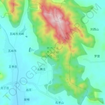
Name: 滕州市莲青山省级地质公园 topographic map, elevation, terrain.
Location: 滕州市莲青山省级地质公园, 滕州市, 枣庄市, 山东省, 中国 (35.24532 117.28276 35.30192 117.32255)
Average elevation: 771 ft
Minimum elevation: 394 ft
Maximum elevation: 1,965 ft
Other topographic maps
Click on a map to view its topography, its elevation and its terrain.