
Thank you for supporting this site ❤️
Make a donation
Make a donation
Gear up for your next adventure:
As an Amazon Associate, this site earns from qualifying purchases at no extra cost to you.
Musikot topographic map
Click on the map to display elevation.
Thank you for supporting this site ❤️
Make a donation
Make a donation
Gear up for your next adventure:
As an Amazon Associate, this site earns from qualifying purchases at no extra cost to you.
About this map
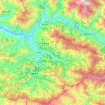
Name: Musikot topographic map, elevation, terrain.
Location: Musikot, Western Rukum District, Karnali Pradesh, 22000, Nepal (28.55177 82.36768 28.67412 82.58138)
Average elevation: 5,715 ft
Minimum elevation: 2,657 ft
Maximum elevation: 10,571 ft
Thank you for supporting this site ❤️
Make a donation
Make a donation
Gear up for your next adventure:
As an Amazon Associate, this site earns from qualifying purchases at no extra cost to you.