
Ivanjica Municipality topographic map
Interactive map
Click on the map to display elevation.
About this map
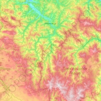
Name: Ivanjica Municipality topographic map, elevation, terrain.
Average elevation: 3,409 ft
Minimum elevation: 1,230 ft
Maximum elevation: 5,988 ft
Other topographic maps
Click on a map to view its topography, its elevation and its terrain.
Корићани
Serbia > Central Serbia > Moravica Administrative District > Mrcajevci
Average elevation: 988 ft
Suvobor
Serbia > Central Serbia > Moravica Administrative District > Gornji Milanovac Municipality
Suvobor (Serbian Cyrillic: Сувобор) is a mountain in central Serbia, near the town of Gornji Milanovac. Its highest peak Suvobor has an elevation of 866 m (2,841 ft) above sea level.
Average elevation: 2,388 ft
Горњи Бранетићи
Serbia > Central Serbia > Moravica Administrative District > Gornji Milanovac Municipality
Average elevation: 1,759 ft
Gornji Milanovac
Serbia > Central Serbia > Moravica Administrative District > Gornji Milanovac Municipality
Gornji Milanovac and the villages of Varnice, Zagradje, Dragolj and Trudelj are dominated by the Ostrvica Massif. The elevation of Ostrvica is 758 metres (2,487 ft). Ostrvica is actually the remains of a destroyed volcanic cone. In May 2009, Ostrvica was declared a natural monument. In the middle of the last…
Average elevation: 1,352 ft
Pranjani
Serbia > Central Serbia > Moravica Administrative District > Gornji Milanovac Municipality
Average elevation: 1,385 ft
Rudnik
Serbia > Central Serbia > Moravica Administrative District > Gornji Milanovac Municipality
Average elevation: 2,034 ft
Donja Vrbava
Serbia > Central Serbia > Moravica Administrative District > Gornji Milanovac Municipality
Average elevation: 1,762 ft
Ivanjica
Serbia > Central Serbia > Moravica Administrative District > Ivanjica Municipality
Ivanjica lies in the southwest of Serbia, at the bank of the Moravica river. It is surrounded by the mountain ranges of Golija, Javor, Mučanj, Čemerno and Radočelo and is in a valley. Ivanjica's highest elevation is 1833 m, at the Jankov Kamen peak. The mountains in this area belong to the Dinaric range.…
Average elevation: 2,198 ft
Brusnik
Serbia > Central Serbia > Moravica Administrative District > Ivanjica Municipality
Average elevation: 3,944 ft