
Make a donation
Gear up for your next adventure:
As an Amazon Associate, this site earns from qualifying purchases at no extra cost to you.
Ronsele topographic map
Click on the map to display elevation.
Make a donation
Gear up for your next adventure:
As an Amazon Associate, this site earns from qualifying purchases at no extra cost to you.
Ronsele
Ronsele ligt in Zandig Vlaanderen nabij de cuesta van Oedelem-Zomergem, met de kom op ongeveer 12,5 meter hoogte. In het westen ligt het hoogste punt, de Steenberg, op 26 meter hoogte. In het oosten ligt het Schipdonkkanaal, waarin ter hoogte van Ronsele ook de Lieve uitmondt. De hoogte bedraagt hier slechts 9 meter. Ten noordwesten van Ronsele ligt het Maldegemveld.
Make a donation
Gear up for your next adventure:
As an Amazon Associate, this site earns from qualifying purchases at no extra cost to you.
About this map
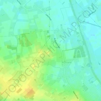
Name: Ronsele topographic map, elevation, terrain.
Location: Ronsele, Lievegem, Gent, Oost-Vlaanderen, 9932, België (51.12606 3.53115 51.14098 3.56128)
Average elevation: 36 ft
Minimum elevation: 7 ft
Maximum elevation: 92 ft
Make a donation
Gear up for your next adventure:
As an Amazon Associate, this site earns from qualifying purchases at no extra cost to you.
Other topographic maps
Click on a map to view its topography, its elevation and its terrain.