
Thank you for supporting this site ❤️
Make a donation
Make a donation
Gear up for your next adventure:
As an Amazon Associate, this site earns from qualifying purchases at no extra cost to you.
Rajakkad topographic map
Click on the map to display elevation.
Thank you for supporting this site ❤️
Make a donation
Make a donation
Gear up for your next adventure:
As an Amazon Associate, this site earns from qualifying purchases at no extra cost to you.
About this map
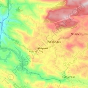
Name: Rajakkad topographic map, elevation, terrain.
Location: Rajakkad, NR city, Udumbanchola, Idukki, Kerala, 685566, India (9.93391 77.05681 9.98952 77.12376)
Average elevation: 2,805 ft
Minimum elevation: 1,834 ft
Maximum elevation: 3,789 ft
Thank you for supporting this site ❤️
Make a donation
Make a donation
Gear up for your next adventure:
As an Amazon Associate, this site earns from qualifying purchases at no extra cost to you.