
Make a donation
Gear up for your next adventure:
As an Amazon Associate, this site earns from qualifying purchases at no extra cost to you.
Dublin topographic map
Click on the map to display elevation.
Make a donation
Gear up for your next adventure:
As an Amazon Associate, this site earns from qualifying purchases at no extra cost to you.
Dublin
According to the United States Census Bureau, the town has a total area of 29.0 square miles (75.1 km2), of which 27.9 square miles (72.2 km2) are land and 1.1 square miles (2.8 km2) are water, comprising 3.78% of the town. The northern slopes of Mount Monadnock occupy the southern part of town. The highest point in Dublin is along Monadnock's northeastern ridge, where the elevation reaches 2,834 feet (864 m) above sea level at the town line. Roughly the western half of Dublin lies within the Connecticut River watershed, drained by tributaries of the Ashuelot River, with the eastern half located in the Merrimack River watershed, drained by tributaries of the Contoocook River.
Make a donation
Gear up for your next adventure:
As an Amazon Associate, this site earns from qualifying purchases at no extra cost to you.
About this map
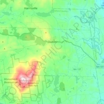
Name: Dublin topographic map, elevation, terrain.
Location: Dublin, Cheshire County, New Hampshire, 03444, United States (42.86512 -72.15593 42.92252 -71.99069)
Average elevation: 1,312 ft
Minimum elevation: 722 ft
Maximum elevation: 3,117 ft
Cheshire County trails, hiking, mountain biking, running and outdoor activities
Make a donation
Gear up for your next adventure:
As an Amazon Associate, this site earns from qualifying purchases at no extra cost to you.
Other topographic maps
Click on a map to view its topography, its elevation and its terrain.
Stone Pond
United States > New Hampshire > Cheshire County > Marlow > Gee Mill
Average elevation: 1,411 ft
Mount Monadnock
United States > New Hampshire > Cheshire County > Jaffrey
From the base to the summit, floral species diminish with increasingly shallow soil levels. The summit is home to many different specialized sub-alpine species which can retain moisture for long periods of time. Alpine and sub-alpine species include mountain ash, cotton grass, sheep laurel, mountain sandwort,…
Average elevation: 2,254 ft
Make a donation
Gear up for your next adventure:
As an Amazon Associate, this site earns from qualifying purchases at no extra cost to you.
Fitzwilliam Depot
United States > New Hampshire > Cheshire County > Fitzwilliam
Average elevation: 1,145 ft
Mount Monadnock
United States > New Hampshire > Cheshire County > Jaffrey
From the base to the summit, floral species diminish with increasingly shallow soil levels. The summit is home to many different specialized sub-alpine species which can retain moisture for long periods of time. Alpine and sub-alpine species include mountain ash, cotton grass, sheep laurel, mountain sandwort,…
Average elevation: 2,254 ft
Camp Notre Dame
United States > New Hampshire > Cheshire County > Chesterfield
Average elevation: 732 ft
Make a donation
Gear up for your next adventure:
As an Amazon Associate, this site earns from qualifying purchases at no extra cost to you.
Mount Monadnock
United States > New Hampshire > Cheshire County > Jaffrey
From the base to the summit, floral species diminish with increasingly shallow soil levels. The summit is home to many different specialized sub-alpine species which can retain moisture for long periods of time. Alpine and sub-alpine species include mountain ash, cotton grass, sheep laurel, mountain sandwort,…
Average elevation: 2,254 ft
Make a donation
Gear up for your next adventure:
As an Amazon Associate, this site earns from qualifying purchases at no extra cost to you.
Gilboa Mountain
United States > New Hampshire > Cheshire County > Westmoreland
Average elevation: 1,086 ft
West Chesterfield
United States > New Hampshire > Cheshire County > Chesterfield
Average elevation: 551 ft