
Pleinfeld topographic map
Click on the map to display elevation.
Pleinfeld
Pleinfeld is situated on the rivers Swabian Rezat and Arbach, 8 kilometres (5.0 mi) north of Weißenburg in Bayern, and 45 kilometres (28 mi) south of Nuremberg. Other rivers in the municipality area are Brombach river and Banzerbach river, both tributary of the Swabian Rezat. The town's altitude is around 382 metres (1,253 feet) above sea level. The highest point of the municipality is located near Dorsbrunn, 505 m (1,657 ft) asl. Pleinfeld is the biggest town at the Großer Brombachsee, a lake in the Franconian Lake District. Simultaneously, Pleinfeld is located on the most northern part of the Altmühl Valley Nature Park.
About this map
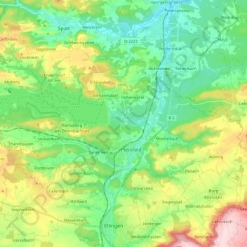
Name: Pleinfeld topographic map, elevation, terrain.
Location: Pleinfeld, Weißenburg-Gunzenhausen, Bavaria, 91785, Germany (49.08332 10.87587 49.15750 11.09330)
Average elevation: 1,414 ft
Minimum elevation: 1,122 ft
Maximum elevation: 2,028 ft
Other topographic maps
Click on a map to view its topography, its elevation and its terrain.
Windischhausen
Germany > Bavaria > Weißenburg-Gunzenhausen > Treuchtlingen
Average elevation: 1,801 ft