Geolocate

Whiteley topographic map

Click on the map to display elevation.

About this map

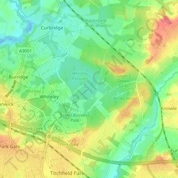
Name: Whiteley topographic map, elevation, terrain.

Location: Whiteley, Winchester, Hampshire, England, United Kingdom (50.86377 -1.26246 50.90869 -1.21633)

Average elevation: 89 ft

Minimum elevation: -16 ft

Maximum elevation: 220 ft

Other topographic maps

Click on a map to view its topography, its elevation and its terrain.

Flagpond Copse

United Kingdom > England > Hampshire > Winchester

Average elevation: 85 ft

Pitt

United Kingdom > England > Hampshire > Winchester > Pitt

Average elevation: 335 ft

Gear up for your next adventure:

🦶Carbon Trekking Poles - Reduce knee impact on steep descents with ultra-light poles
⛑️Personal Locator Beacon - Safety beacon for emergencies
📷Action Cameras - Rugged cameras to document your journeys across rugged terrain
🥾Men's Hiking Boots - Durable, waterproof footwear for rugged terrain and steep inclines
🥄Camping Utensil Set - Lightweight utensils for outdoor meals

As an Amazon Associate, this site earns from qualifying purchases at no extra cost to you.