Geolocate

Auchtermuchty topographic map

Click on the map to display elevation.

About this map

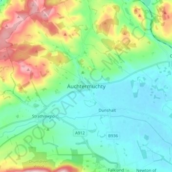
Name: Auchtermuchty topographic map, elevation, terrain.

Location: Auchtermuchty, Fife, Scotland, KY14 7AP, United Kingdom (56.25208 -3.27283 56.33208 -3.19283)

Average elevation: 354 ft

Minimum elevation: 121 ft

Maximum elevation: 958 ft

Other topographic maps

Click on a map to view its topography, its elevation and its terrain.

Rosyth

United Kingdom > Scotland > Fife

Average elevation: 75 ft

Auchtertool

United Kingdom > Scotland > Fife

Average elevation: 371 ft

Gear up for your next adventure:

🔦Compact Flashlight - Reliable flashlight for emergencies
👟Trail Running Shoes - Lightweight shoes for trail runners
🪶Multi‑Purpose Knife - Useful blade for camp and trail
🛏️Cold Weather Sleeping Bag - Warm sleeping bag for cold conditions
🧭Pro Hiking Compasses - High-accuracy liquid-filled compasses for topographic orientation

As an Amazon Associate, this site earns from qualifying purchases at no extra cost to you.