Geolocate

Rosyth topographic map

Click on the map to display elevation.

About this map

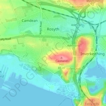
Name: Rosyth topographic map, elevation, terrain.

Location: Rosyth, Fife, Scotland, United Kingdom (56.01458 -3.46476 56.04760 -3.40341)

Average elevation: 75 ft

Minimum elevation: -16 ft

Maximum elevation: 269 ft

Other topographic maps

Click on a map to view its topography, its elevation and its terrain.

Anstruther

United Kingdom > Scotland > Fife

Average elevation: 75 ft

Auchtermuchty

United Kingdom > Scotland > Fife

Average elevation: 354 ft

Cupar

United Kingdom > Scotland > Fife

Average elevation: 246 ft

Leuchars

United Kingdom > Scotland > Fife > Leuchars

Average elevation: 72 ft

Rankeilour

United Kingdom > Scotland > Fife > Springfield

Average elevation: 157 ft

Crail

United Kingdom > Scotland > Fife

Average elevation: 69 ft

Gear up for your next adventure:

🪶Survival Guide Book - Expert advice for emergency preparedness
🧼Biodegradable Camping Soap - Eco‑friendly soap for outdoor hygiene
🌡️Portable Weather Meter - Track weather conditions on the trail
🧤Tactile Hiking Gloves - Keep hands warm while operating GPS and smartphone screens
🪓Survival Multi‑Tool - Versatile tool for camp and trail tasks

As an Amazon Associate, this site earns from qualifying purchases at no extra cost to you.