
Kaufering topographic map
Click on the map to display elevation.
Kaufering
Die Landsberger Verkehrsgemeinschaft betreibt in Kaufering die Ortsbuslinie 92. Die Benutzung ist seit 12. Dezember 2021 kostenlos. Die Betriebskosten in Höhe von ca. 20.000 € will die Gemeinde übernehmen.
About this map
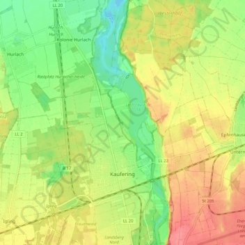
Name: Kaufering topographic map, elevation, terrain.
Average elevation: 1,932 ft
Minimum elevation: 1,808 ft
Maximum elevation: 2,067 ft
Other topographic maps
Click on a map to view its topography, its elevation and its terrain.
Geretshausen
Deutschland > Bayern > Landkreis Landsberg am Lech
Das Pfarrdorf liegt etwa eineinhalb Kilometer ostsüdöstlich der Ortsmitte von Weil auf einer Höhe von 591 m ü. NHN. Naturräumlich befindet es sich im Lechrain am östlichen Hochufer des Verlorenen Baches, dem dort auch der Sägmühlbach und der Dorfgraben zufließen.
Average elevation: 1,929 ft
Dettenschwang
Deutschland > Bayern > Landkreis Landsberg am Lech > Dießen am Ammersee
Das Pfarrdorf Dettenschwang liegt circa sechs Kilometer westlich von Dießen am Ammersee auf einem Höhenrücken in einer eiszeitlichen Jungmoränenlandschaft.
Average elevation: 2,215 ft
Thalhofen
Deutschland > Bayern > Landkreis Landsberg am Lech > Landsberg am Lech
Average elevation: 2,103 ft
Riederau
Deutschland > Bayern > Landkreis Landsberg am Lech > Dießen am Ammersee
Average elevation: 1,847 ft
Hechenwang
Deutschland > Bayern > Landkreis Landsberg am Lech
Das Kirchdorf liegt auf einer Höhe von 594 m ü. NHN etwa zwei Kilometer südöstlich vom Gemeindehauptort Windach und zwei Kilometer westlich von Schondorf am Ammersee am Lauf der Schweinach.
Average elevation: 1,916 ft
Oberbeuern
Deutschland > Bayern > Landkreis Landsberg am Lech > Dießen am Ammersee
Average elevation: 2,133 ft
Lechrain
Deutschland > Bayern > Landkreis Landsberg am Lech > Denklingen > Guttenstall
Average elevation: 2,247 ft
Pitzling
Deutschland > Bayern > Landkreis Landsberg am Lech > Landsberg am Lech
Average elevation: 2,070 ft
Erpfting
Deutschland > Bayern > Landkreis Landsberg am Lech > Landsberg am Lech
Average elevation: 2,060 ft
Oberdießen
Deutschland > Bayern > Landkreis Landsberg am Lech > Oberdießen
Average elevation: 2,165 ft
Pessenhausen
Deutschland > Bayern > Landkreis Landsberg am Lech > Pessenhausen
Average elevation: 2,316 ft
Dettenhofen
Deutschland > Bayern > Landkreis Landsberg am Lech > Dießen am Ammersee
Average elevation: 2,172 ft