
Make a donation
Gear up for your next adventure:
As an Amazon Associate, this site earns from qualifying purchases at no extra cost to you.
San Mateo topographic map
Click on the map to display elevation.
Make a donation
Gear up for your next adventure:
As an Amazon Associate, this site earns from qualifying purchases at no extra cost to you.
San Mateo
San Mateo, located in the province of Rizal in the Calabarzon region, features a diverse topography characterized by a mix of rolling hills and mountainous terrain. The elevation in the area varies significantly, ranging from the relatively low-lying plains at around 16 feet (5 meters) above sea level, up to steep, mountainous regions that rise to over 1,380 feet (422 meters). This terrain influences the local climate and water resources, with elevated areas supporting watershed protection efforts and abundant groundwater sources. The natural landscape supports rich biodiversity, but the steep slopes also contribute to challenges such as flooding and landslides during heavy rains.
Make a donation
Gear up for your next adventure:
As an Amazon Associate, this site earns from qualifying purchases at no extra cost to you.
About this map
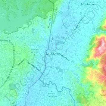
Name: San Mateo topographic map, elevation, terrain.
Location: San Mateo, Rizal, Calabarzon, 1631, Philippines (14.65519 121.07740 14.73519 121.15740)
Average elevation: 223 ft
Minimum elevation: 16 ft
Maximum elevation: 1,385 ft
Make a donation
Gear up for your next adventure:
As an Amazon Associate, this site earns from qualifying purchases at no extra cost to you.