Geolocate

Hyde topographic map

Click on the map to display elevation.

About this map

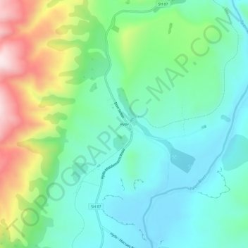
Name: Hyde topographic map, elevation, terrain.

Location: Hyde, Dunedin City, Otago, New Zealand (-45.31817 170.23650 -45.27817 170.27650)

Average elevation: 1,388 ft

Minimum elevation: 889 ft

Maximum elevation: 2,635 ft

Gear up for your next adventure:

📚Navigation Handbooks - Master the art of reading topographic maps and using a compass
📌Outdoor GPS Map App - Apps and devices for digital topographic navigation
🪑Portable Camp Table - Compact table for campsite meals
🔦Compact Flashlight - Reliable flashlight for emergencies
📻Weather Alert Radios - Stay informed of storm risks while off-the-grid

As an Amazon Associate, this site earns from qualifying purchases at no extra cost to you.