
Thank you for supporting this site ❤️
Make a donation
Make a donation
Gear up for your next adventure:
As an Amazon Associate, this site earns from qualifying purchases at no extra cost to you.
Protivín topographic map
Click on the map to display elevation.
Thank you for supporting this site ❤️
Make a donation
Make a donation
Gear up for your next adventure:
As an Amazon Associate, this site earns from qualifying purchases at no extra cost to you.
About this map
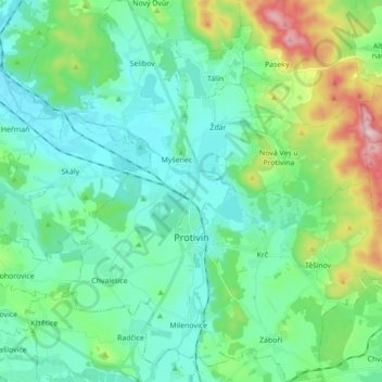
Name: Protivín topographic map, elevation, terrain.
Location: Protivín, okres Písek, Southwest, 398 11, Czechia (49.15674 14.15421 49.27082 14.31395)
Average elevation: 1,404 ft
Minimum elevation: 1,207 ft
Maximum elevation: 2,080 ft
Thank you for supporting this site ❤️
Make a donation
Make a donation
Gear up for your next adventure:
As an Amazon Associate, this site earns from qualifying purchases at no extra cost to you.