
Make a donation
Gear up for your next adventure:
As an Amazon Associate, this site earns from qualifying purchases at no extra cost to you.
Philippi topographic map
Click on the map to display elevation.
Make a donation
Gear up for your next adventure:
As an Amazon Associate, this site earns from qualifying purchases at no extra cost to you.
Philippi
Throughout its history, Philippi has suffered from floods because of its proximity to the river and the relatively low elevation of most of the town. The most damaging of these came in November 1985. The town has since adopted a flood plain management plan.
Make a donation
Gear up for your next adventure:
As an Amazon Associate, this site earns from qualifying purchases at no extra cost to you.
About this map
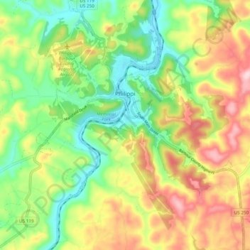
Name: Philippi topographic map, elevation, terrain.
Average elevation: 1,608 ft
Minimum elevation: 1,273 ft
Maximum elevation: 2,054 ft
Make a donation
Gear up for your next adventure:
As an Amazon Associate, this site earns from qualifying purchases at no extra cost to you.
Other topographic maps
Click on a map to view its topography, its elevation and its terrain.