Geolocate

Midland topographic map

Click on the map to display elevation.

About this map

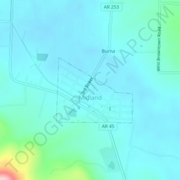
Name: Midland topographic map, elevation, terrain.

Location: Midland, Sebastian County, Arkansas, 72945, United States (35.08931 -94.35921 35.09910 -94.34520)

Average elevation: 597 ft

Minimum elevation: 512 ft

Maximum elevation: 1,181 ft

Sebastian County trails, hiking, mountain biking, running and outdoor activities

Other topographic maps

Click on a map to view its topography, its elevation and its terrain.

Jenson

United States > Arkansas > Sebastian County

Average elevation: 581 ft

Poteau Mountain

United States > Arkansas > Sebastian County

Average elevation: 1,493 ft

Saw Mill

United States > Arkansas > Sebastian County > Fort Smith > Saw Mill

Average elevation: 548 ft

Gear up for your next adventure:

🧭Pro Hiking Compasses - High-accuracy liquid-filled compasses for topographic orientation
👓Polarized Sunglasses - Outdoor sunglasses for glare reduction
🛏️Cold Weather Sleeping Bag - Warm sleeping bag for cold conditions
🪶Camp Gear Gift Set - Perfect gift bundle for outdoor fans
❄️Traction Cleats - Prevent slips on icy trails during winter hikes

As an Amazon Associate, this site earns from qualifying purchases at no extra cost to you.