
Andrews Lake topographic map
Interactive map
Click on the map to display elevation.
About this map
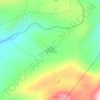
Name: Andrews Lake topographic map, elevation, terrain.
Location: Andrews Lake, San Juan County, Colorado, United States (37.72694 -107.71102 37.72881 -107.70700)
Average elevation: 10,866 ft
Minimum elevation: 10,367 ft
Maximum elevation: 11,686 ft
Other topographic maps
Click on a map to view its topography, its elevation and its terrain.
Silverton
United States > Colorado > San Juan County
Silverton, San Juan County, Colorado, 81433, United States
Average elevation: 9,813 ft
Animas Forks
United States > Colorado > San Juan County
Animas Forks, San Juan County, Colorado, United States
Average elevation: 11,929 ft