
Animas Forks topographic map
Click on the map to display elevation.
Animas Forks
Animas Forks is located on a system of roads known as the Alpine Loop. The loop is a 65-mile (105 km) system of unpaved roads which connects the small mountain towns of Lake City, Ouray, and Silverton. Most of the land in the area is managed by either the U.S. Forest Service or the Bureau of Land Management. The Alpine Loop is visited by over 100,000 people each year. Animas Forks, at an elevation of 11,200 feet (3,400 m), is more than two miles (3 km) above sea level.
About this map
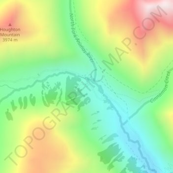
Name: Animas Forks topographic map, elevation, terrain.
Location: Animas Forks, San Juan County, Colorado, United States (37.92086 -107.58124 37.94086 -107.56124)
Average elevation: 11,929 ft
Minimum elevation: 10,768 ft
Maximum elevation: 13,711 ft
San Juan County trails, hiking, mountain biking, running and outdoor activities
Other topographic maps
Click on a map to view its topography, its elevation and its terrain.
Silverton
United States > Colorado > San Juan County
According to the United States Census Bureau, the town has a total area of 0.8 square miles (2.1 km2), all of it land. Silverton is one of the highest towns in the United States, at 9,318 feet (2,840 m) above sea level. The town is located in San Juan County, the highest county in the United States, with a…
Average elevation: 9,813 ft