
Make a donation
Gear up for your next adventure:
As an Amazon Associate, this site earns from qualifying purchases at no extra cost to you.
Collina topographic map
Click on the map to display elevation.
Make a donation
Gear up for your next adventure:
As an Amazon Associate, this site earns from qualifying purchases at no extra cost to you.
Collina
La frazione di Arcigliano, sorge a 298 metri di altitudine su un versante della valle del torrente Torbecchia che sfocia nell'Ombrone nella zona nord-ovest della piana di Pistoia. Dista circa 5 km dal centro cittadino.
Make a donation
Gear up for your next adventure:
As an Amazon Associate, this site earns from qualifying purchases at no extra cost to you.
About this map
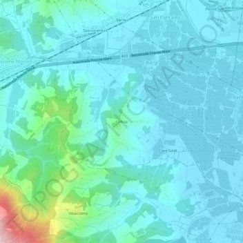
Name: Collina topographic map, elevation, terrain.
Location: Collina, Bargi, Pistoia, Toscana, 51030, Italia (43.88205 10.86131 43.92205 10.90131)
Average elevation: 335 ft
Minimum elevation: 157 ft
Maximum elevation: 1,447 ft
Make a donation
Gear up for your next adventure:
As an Amazon Associate, this site earns from qualifying purchases at no extra cost to you.