
Thank you for supporting this site ❤️
Make a donation
Make a donation
Gear up for your next adventure:
As an Amazon Associate, this site earns from qualifying purchases at no extra cost to you.
Dochamps topographic map
Click on the map to display elevation.
Thank you for supporting this site ❤️
Make a donation
Make a donation
Gear up for your next adventure:
As an Amazon Associate, this site earns from qualifying purchases at no extra cost to you.
About this map
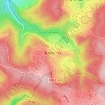
Name: Dochamps topographic map, elevation, terrain.
Location: Dochamps, Manhay, Luxemburg, Wallonië, 6960, België (50.21417 5.60331 50.25417 5.64331)
Average elevation: 1,614 ft
Minimum elevation: 1,089 ft
Maximum elevation: 1,906 ft
Thank you for supporting this site ❤️
Make a donation
Make a donation
Gear up for your next adventure:
As an Amazon Associate, this site earns from qualifying purchases at no extra cost to you.