Geolocate

Mátra topographic map

Click on the map to display elevation.

About this map

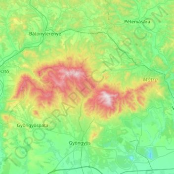
Name: Mátra topographic map, elevation, terrain.

Location: Mátra, Heves, North Hungary, Great Plain and North, Hungary (47.77474 19.68986 48.00584 20.20079)

Average elevation: 935 ft

Minimum elevation: 125 ft

Maximum elevation: 3,330 ft

Other topographic maps

Click on a map to view its topography, its elevation and its terrain.

Gyöngyös

Hungary > Heves

Average elevation: 1,030 ft

Eger

Hungary > Heves

Average elevation: 860 ft

3296

Hungary > Heves > Zaránk

Average elevation: 325 ft

Egerszalók

Hungary > Heves

Average elevation: 656 ft

Ostorosi-tó

Hungary > Heves > Ostoros

Average elevation: 682 ft

Liszkó gyártelep

Hungary > Heves > Sirok

Average elevation: 646 ft

Bélapátfalva

Hungary > Heves

Bélapátfalva is a town in Heves County, in Hungary, located north of the city of Eger. The town is located inside the Eger river valley at an altitude of 311 meters above sea level. Facing the town is the Bél-kő mountain which rises 811 meters and is one of the highest peaks of the Bükk mountains. Because…

Average elevation: 1,355 ft

Adács

Hungary > Heves

Average elevation: 361 ft

Felsőtárkány

Hungary > Heves

Average elevation: 1,362 ft

Parádsasvár

Hungary > Heves

Average elevation: 1,562 ft

Boldog

Hungary > Heves

Average elevation: 377 ft

Eger

Hungary > Heves

Average elevation: 860 ft

Eger

Hungary > Heves

Average elevation: 860 ft

Egerszalóki-víztározó

Hungary > Heves > Egerszalók

Average elevation: 614 ft

Tiszavalki-medence

Hungary > Heves > Poroszló

Average elevation: 285 ft

3336

Hungary > Heves > Bátor

Average elevation: 932 ft

Visonta

Hungary > Heves

Average elevation: 607 ft

Istenmezeje

Hungary > Heves

Average elevation: 965 ft

Szilvásvárad

Hungary > Heves

Average elevation: 1,526 ft

Eger

Hungary > Heves

Average elevation: 860 ft

Gyöngyös

Hungary > Heves > Gyöngyös > Gyöngyös

Average elevation: 646 ft

Eger

Hungary > Heves > Eger

Average elevation: 801 ft

Kerecsend

Hungary > Heves > Kerecsend

Average elevation: 453 ft

Gyöngyöstarján

Hungary > Heves

Average elevation: 1,093 ft

Terpes

Hungary > Heves

Average elevation: 614 ft

Gear up for your next adventure:

🧭Hiking Compass - Precision compass for reliable navigation in the wilderness
🪓Survival Multi‑Tool - Versatile tool for camp and trail tasks
📻Weather Alert Radios - Stay informed of storm risks while off-the-grid
🥾Hiking Shoes - Durable and comfortable shoes for trail hiking
🪶Survival Guide Book - Expert advice for emergency preparedness

As an Amazon Associate, this site earns from qualifying purchases at no extra cost to you.