
Make a donation
Gear up for your next adventure:
As an Amazon Associate, this site earns from qualifying purchases at no extra cost to you.
Haveluloto topographic map
Click on the map to display elevation.
Make a donation
Gear up for your next adventure:
As an Amazon Associate, this site earns from qualifying purchases at no extra cost to you.
About this map
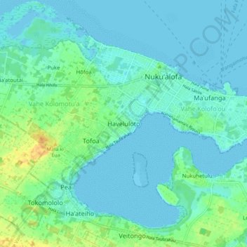
Name: Haveluloto topographic map, elevation, terrain.
Location: Haveluloto, Vahe Kolomotu'a, Tongatapu, Tonga (-21.18961 -175.25556 -21.10961 -175.17556)
Average elevation: 23 ft
Minimum elevation: -3 ft
Maximum elevation: 95 ft
Make a donation
Gear up for your next adventure:
As an Amazon Associate, this site earns from qualifying purchases at no extra cost to you.
Other topographic maps
Click on a map to view its topography, its elevation and its terrain.
Tongatapu
Tongatapu is the main island of Tonga and the site of its capital, Nukuʻalofa. It is located in Tonga's southern island group, to which it gives its name, and is the country's most populous island, with 74,611 residents (2016), 70.5% of the national population, on 260 square kilometres (100 square miles).…
Average elevation: 13 ft