
Thank you for supporting this site ❤️
Make a donation
Make a donation
Gear up for your next adventure:
As an Amazon Associate, this site earns from qualifying purchases at no extra cost to you.
'Alele'uta topographic map
Click on the map to display elevation.
Thank you for supporting this site ❤️
Make a donation
Make a donation
Gear up for your next adventure:
As an Amazon Associate, this site earns from qualifying purchases at no extra cost to you.
About this map
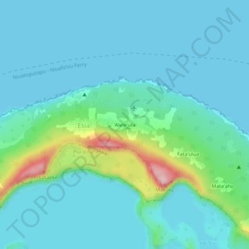
Name: 'Alele'uta topographic map, elevation, terrain.
Location: 'Alele'uta, 'Esia, Vahe Niuafo'ou, Ongo Niua, Tonga (-15.59390 -175.65179 -15.55390 -175.61179)
Average elevation: 115 ft
Minimum elevation: 0 ft
Maximum elevation: 709 ft
Thank you for supporting this site ❤️
Make a donation
Make a donation
Gear up for your next adventure:
As an Amazon Associate, this site earns from qualifying purchases at no extra cost to you.