
Make a donation
Gear up for your next adventure:
As an Amazon Associate, this site earns from qualifying purchases at no extra cost to you.
Joe Morolong Local Municipality topographic map
Click on the map to display elevation.
Make a donation
Gear up for your next adventure:
As an Amazon Associate, this site earns from qualifying purchases at no extra cost to you.
About this map
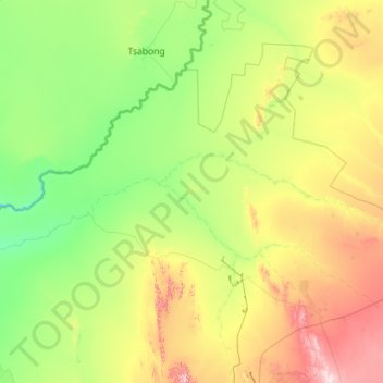
Name: Joe Morolong Local Municipality topographic map, elevation, terrain.
Average elevation: 3,524 ft
Minimum elevation: 2,894 ft
Maximum elevation: 5,912 ft
Make a donation
Gear up for your next adventure:
As an Amazon Associate, this site earns from qualifying purchases at no extra cost to you.
Other topographic maps
Click on a map to view its topography, its elevation and its terrain.
Kuruman
South Africa > Northern Cape > John Taolo Gaetsewe District Municipality > Ga-Segonyana Local Municipality
Average elevation: 4,380 ft
Kuruman
South Africa > Northern Cape > John Taolo Gaetsewe District Municipality > Ga-Segonyana Local Municipality
Average elevation: 4,380 ft
Hotazel
South Africa > Northern Cape > John Taolo Gaetsewe District Municipality > Joe Morolong Local Municipality
Average elevation: 3,478 ft
Dithakong
South Africa > Northern Cape > John Taolo Gaetsewe District Municipality > Joe Morolong Local Municipality
Average elevation: 4,150 ft
Make a donation
Gear up for your next adventure:
As an Amazon Associate, this site earns from qualifying purchases at no extra cost to you.
Kathu
South Africa > Northern Cape > John Taolo Gaetsewe District Municipality > Gamagara Local Municipality
Average elevation: 4,012 ft
Olifantshoek
South Africa > Northern Cape > John Taolo Gaetsewe District Municipality > Gamagara Local Municipality
Average elevation: 4,249 ft
Hotazel
South Africa > Northern Cape > John Taolo Gaetsewe District Municipality > Joe Morolong Local Municipality
Average elevation: 3,478 ft
Kathu
South Africa > Northern Cape > John Taolo Gaetsewe District Municipality > Gamagara Local Municipality
Average elevation: 4,012 ft
Make a donation
Gear up for your next adventure:
As an Amazon Associate, this site earns from qualifying purchases at no extra cost to you.
Hotazel
South Africa > Northern Cape > John Taolo Gaetsewe District Municipality > Joe Morolong Local Municipality
Average elevation: 3,478 ft
Kathu
South Africa > Northern Cape > John Taolo Gaetsewe District Municipality > Gamagara Local Municipality
Average elevation: 4,012 ft
Kuruman
South Africa > Northern Cape > John Taolo Gaetsewe District Municipality > Ga-Segonyana Local Municipality
Average elevation: 4,380 ft
Olifantshoek
South Africa > Northern Cape > John Taolo Gaetsewe District Municipality > Gamagara Local Municipality
Average elevation: 4,249 ft
Make a donation
Gear up for your next adventure:
As an Amazon Associate, this site earns from qualifying purchases at no extra cost to you.
Mothibistad
South Africa > Northern Cape > John Taolo Gaetsewe District Municipality > Ga-Segonyana Local Municipality
Average elevation: 4,370 ft
Gamagara
South Africa > Northern Cape > John Taolo Gaetsewe District Municipality
Average elevation: 3,865 ft
Mothibistad
South Africa > Northern Cape > John Taolo Gaetsewe District Municipality > Ga-Segonyana Local Municipality
Average elevation: 4,370 ft