Geolocate

Balligui topographic map

Click on the map to display elevation.

About this map

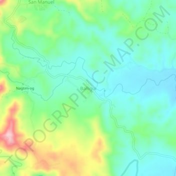
Name: Balligui topographic map, elevation, terrain.

Location: Balligui, Quirino, Cagayan Valley, Philippines (16.34505 121.61297 16.38505 121.65297)

Average elevation: 732 ft

Minimum elevation: 525 ft

Maximum elevation: 1,211 ft

Other topographic maps

Click on a map to view its topography, its elevation and its terrain.

Maddela

Philippines > Quirino

Average elevation: 1,463 ft

Cagayan River

Philippines > Quirino

Average elevation: 1,453 ft

Addalam River

Philippines > Quirino

Average elevation: 1,496 ft

Saguday

Philippines > Quirino

Average elevation: 367 ft

Aglipay

Philippines > Quirino

Average elevation: 607 ft

Cabarroguis

Philippines > Quirino

Average elevation: 971 ft

Nagtipunan

Philippines > Quirino

Average elevation: 1,795 ft

Diffun

Philippines > Quirino

Average elevation: 827 ft

Maddela

Philippines > Quirino

Average elevation: 1,463 ft

Gear up for your next adventure:

🎒Trekking Poles - Sturdy poles for balance and stability on rough terrain
🥾Women's Hiking Boots - Top-rated trail boots with ankle support and superior grip
🧭GPS Watch Accessories - Bands and chargers for GPS watches
🧭Pro Hiking Compasses - High-accuracy liquid-filled compasses for topographic orientation
🔭Compact Binoculars - HD vision for scouting terrain and identifying distant landmarks

As an Amazon Associate, this site earns from qualifying purchases at no extra cost to you.