Geolocate

Telavi topographic map

Click on the map to display elevation.

About this map

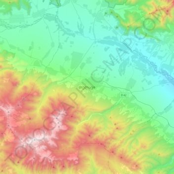
Name: Telavi topographic map, elevation, terrain.

Location: Telavi, Telavi Municipality, Kakheti, 2200, Georgia (41.75829 45.31465 42.07829 45.63465)

Average elevation: 2,671 ft

Minimum elevation: 997 ft

Maximum elevation: 6,509 ft

Other topographic maps

Click on a map to view its topography, its elevation and its terrain.

Telavi

Georgia > Telavi Municipality

Average elevation: 2,238 ft

Gear up for your next adventure:

🌡️Handheld Weather Meters - Measure wind, temp, and pressure for safe mountain travel
🛡️Insect Repellent - Protection against bugs during outdoor activities
👓Polarized Sunglasses - Outdoor sunglasses for glare reduction
🚁Photography Drones - Capture stunning aerial views of landforms and topography
🪶Survival Guide Book - Expert advice for emergency preparedness

As an Amazon Associate, this site earns from qualifying purchases at no extra cost to you.