Geolocate

Hebron topographic map

Click on the map to display elevation.

About this map

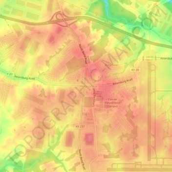
Name: Hebron topographic map, elevation, terrain.

Location: Hebron, Boone County, Kentucky, 41048, United States (39.04581 -84.72276 39.08581 -84.68276)

Average elevation: 863 ft

Minimum elevation: 696 ft

Maximum elevation: 928 ft

Boone County trails, hiking, mountain biking, running and outdoor activities

Other topographic maps

Click on a map to view its topography, its elevation and its terrain.

Burlington

United States > Kentucky > Boone County

Average elevation: 820 ft

Walton

United States > Kentucky > Boone County

Average elevation: 866 ft

Walton

United States > Kentucky > Boone County

Average elevation: 866 ft

Gear up for your next adventure:

💧Water Filtration Bottles - Safely drink from streams and lakes while exploring
🌡️Portable Weather Meter - Track weather conditions on the trail
🔋Rechargeable Batteries - Power up your outdoor devices
🏫Relief Map Kits - Hands-on tools for teaching landforms and elevation
🌲Outdoor Survival Books - Best books on survival skills

As an Amazon Associate, this site earns from qualifying purchases at no extra cost to you.