
Make a donation
Gear up for your next adventure:
As an Amazon Associate, this site earns from qualifying purchases at no extra cost to you.
Glarey topographic map
Click on the map to display elevation.
Make a donation
Gear up for your next adventure:
As an Amazon Associate, this site earns from qualifying purchases at no extra cost to you.
About this map
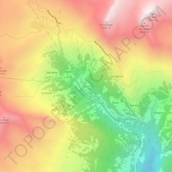
Name: Glarey topographic map, elevation, terrain.
Location: Glarey, Savièse, Sion, Wallis, 1965, Switzerland (46.28937 7.28729 46.32937 7.32729)
Average elevation: 6,522 ft
Minimum elevation: 3,642 ft
Maximum elevation: 9,144 ft
Make a donation
Gear up for your next adventure:
As an Amazon Associate, this site earns from qualifying purchases at no extra cost to you.
Other topographic maps
Click on a map to view its topography, its elevation and its terrain.
Les Agettes
Switzerland > Wallis > Sion > Sion
The former municipality was located in the Hérens district, on the slopes south of Sion and above the Rhone valley. It is composed of three small villages: Crête-à-l'Œil, La Vernaz, and Les Agettes, which range in altitude between 980 and 1,200 m (3,220 and 3,940 ft) as well as scattered alpine pastures…
Average elevation: 4,577 ft