Geolocate

Alia topographic map

Click on the map to display elevation.

About this map

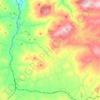
Name: Alia topographic map, elevation, terrain.

Location: Alia, Palermo, Sicily, 90021, Italy (37.71146 13.66516 37.80949 13.79361)

Average elevation: 1,880 ft

Minimum elevation: 794 ft

Maximum elevation: 3,251 ft

Other topographic maps

Click on a map to view its topography, its elevation and its terrain.

Sorgente di Montescuro

Italy > Sicily > Palermo > Prizzi

Average elevation: 2,726 ft

Bellacera

Italy > Sicily > Palermo > Santa Flavia

Average elevation: 531 ft

Finale

Italy > Sicily > Palermo

Average elevation: 276 ft

Santa Lucia

Italy > Sicily > Palermo > Cefalù

Average elevation: 167 ft

San Carlo

Italy > Sicily > Palermo > Chiusa Sclafani

Average elevation: 955 ft

Gear up for your next adventure:

🧯Emergency Survival Kit - All‑in‑one survival essentials for the backcountry
🚗GPS Dash Cams - Record your scenic drives through mountain passes and canyons
🪶Wildlife Field Guides - Learn animal tracking and species ID
📚Navigation Handbooks - Master the art of reading topographic maps and using a compass
💧Water Purification System - Clean water on the trail with reliable purifiers

As an Amazon Associate, this site earns from qualifying purchases at no extra cost to you.