
Make a donation
Gear up for your next adventure:
As an Amazon Associate, this site earns from qualifying purchases at no extra cost to you.
Aigre topographic map
Click on the map to display elevation.
Make a donation
Gear up for your next adventure:
As an Amazon Associate, this site earns from qualifying purchases at no extra cost to you.
Aigre
The south of the commune is a plateau. The Aume Valley is near the north-eastern border near the town. The highest point of the commune is at an altitude of 129m located on the south-eastern boundary (IGN marker). The lowest point is 62m located on the eastern boundary along the Aume at Aizef. The town is built in an old loop of the river and is 65m above sea level.
Make a donation
Gear up for your next adventure:
As an Amazon Associate, this site earns from qualifying purchases at no extra cost to you.
About this map
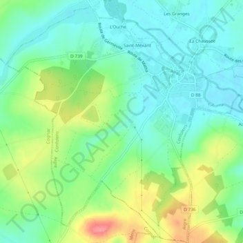
Name: Aigre topographic map, elevation, terrain.
Average elevation: 295 ft
Minimum elevation: 203 ft
Maximum elevation: 479 ft
Make a donation
Gear up for your next adventure:
As an Amazon Associate, this site earns from qualifying purchases at no extra cost to you.