
Hidden Valley topographic map
Click on the map to display elevation.
About this map
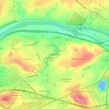
Name: Hidden Valley topographic map, elevation, terrain.
Average elevation: 154 ft
Minimum elevation: -69 ft
Maximum elevation: 302 ft
Montgomery County trails, hiking, mountain biking, running and outdoor activities
Other topographic maps
Click on a map to view its topography, its elevation and its terrain.
Valley Forge National Historical Park
United States > Pennsylvania > Montgomery County > Upper Merion Township > King of Prussia
Average elevation: 174 ft
King of Prussia
United States > Pennsylvania > Montgomery County > Upper Merion Township > King of Prussia
Average elevation: 194 ft
King of Prussia
United States > Pennsylvania > Montgomery County > Upper Merion Township
Average elevation: 194 ft