
Thank you for supporting this site ❤️
Make a donation
Make a donation
Gear up for your next adventure:
As an Amazon Associate, this site earns from qualifying purchases at no extra cost to you.
Castillazuelo topographic map
Click on the map to display elevation.
Thank you for supporting this site ❤️
Make a donation
Make a donation
Gear up for your next adventure:
As an Amazon Associate, this site earns from qualifying purchases at no extra cost to you.
About this map
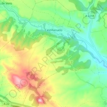
Name: Castillazuelo topographic map, elevation, terrain.
Location: Castillazuelo, Somontano de Barbastro, Huesca, Aragon, Spain (42.03252 0.01551 42.08263 0.08308)
Average elevation: 1,411 ft
Minimum elevation: 1,112 ft
Maximum elevation: 1,923 ft
Thank you for supporting this site ❤️
Make a donation
Make a donation
Gear up for your next adventure:
As an Amazon Associate, this site earns from qualifying purchases at no extra cost to you.
Other topographic maps
Click on a map to view its topography, its elevation and its terrain.
Sosas
Spain > Aragon > Somontano de Barbastro > Hoz y Costeán > Hoz de Barbastro
Average elevation: 1,972 ft