Geolocate

Furbo topographic map

Click on the map to display elevation.

About this map

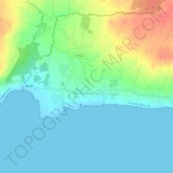
Name: Furbo topographic map, elevation, terrain.

Location: Furbo, County Galway, Connacht, H91 KX27, Ireland (53.24529 -9.22033 53.25447 -9.19918)

Average elevation: 52 ft

Minimum elevation: -3 ft

Maximum elevation: 177 ft

Other topographic maps

Click on a map to view its topography, its elevation and its terrain.

Glassilaun Beach

Ireland > County Galway

Average elevation: 36 ft

Derryclare

Ireland > County Galway

Average elevation: 915 ft

Claregalway

Ireland > County Galway

Average elevation: 52 ft

Gurteen

Ireland > County Galway

Average elevation: 292 ft

Costelloe

Ireland > County Galway

Average elevation: 39 ft

Kilconnell

Ireland > County Galway

Average elevation: 302 ft

Galway Bay

Ireland > County Galway

Average elevation: 115 ft

Gear up for your next adventure:

🎒Outdoor Daypacks - Lightweight backpacks designed for carrying maps and essential gear
⛑️Personal Locator Beacon - Safety beacon for emergencies
🛰️Satellite Messengers - Emergency SOS and two-way messaging for off-grid adventures
🏕️Family Camping Gear - Essentials for group camping trips
🧭Hiking Compass - Precision compass for reliable navigation in the wilderness

As an Amazon Associate, this site earns from qualifying purchases at no extra cost to you.