
Make a donation
Gear up for your next adventure:
As an Amazon Associate, this site earns from qualifying purchases at no extra cost to you.
Indiana topographic map
Click on the map to display elevation.
Make a donation
Gear up for your next adventure:
As an Amazon Associate, this site earns from qualifying purchases at no extra cost to you.
About this map
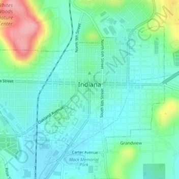
Name: Indiana topographic map, elevation, terrain.
Location: Indiana, Indiana County, Pennsylvania, United States (40.61250 -79.17403 40.63155 -79.13834)
Average elevation: 1,339 ft
Minimum elevation: 1,230 ft
Maximum elevation: 1,654 ft
Indiana County trails, hiking, mountain biking, running and outdoor activities
Make a donation
Gear up for your next adventure:
As an Amazon Associate, this site earns from qualifying purchases at no extra cost to you.
Other topographic maps
Click on a map to view its topography, its elevation and its terrain.
Claypoole Heights
United States > Pennsylvania > Indiana County > White Township
Average elevation: 1,381 ft
West Lebanon
United States > Pennsylvania > Indiana County > Young Township
Average elevation: 1,194 ft
Make a donation
Gear up for your next adventure:
As an Amazon Associate, this site earns from qualifying purchases at no extra cost to you.
Rochester Mills
United States > Pennsylvania > Indiana County > Grant Township
Average elevation: 1,516 ft
Marchand
United States > Pennsylvania > Indiana County > North Mahoning Township
Average elevation: 1,516 ft
Make a donation
Gear up for your next adventure:
As an Amazon Associate, this site earns from qualifying purchases at no extra cost to you.
Josephine
United States > Pennsylvania > Indiana County > Burrell Township
Average elevation: 1,194 ft
Dilltown
United States > Pennsylvania > Indiana County > East Wheatfield Township
Average elevation: 1,555 ft
Clarksburg
United States > Pennsylvania > Indiana County > Conemaugh Township
Average elevation: 1,112 ft
Make a donation
Gear up for your next adventure:
As an Amazon Associate, this site earns from qualifying purchases at no extra cost to you.
Arcadia
United States > Pennsylvania > Indiana County > Montgomery Township
Average elevation: 1,673 ft
Brush Valley
United States > Pennsylvania > Indiana County > Brush Valley Township
Average elevation: 1,463 ft
Chambersville
United States > Pennsylvania > Indiana County > Rayne Township
Average elevation: 1,230 ft
Make a donation
Gear up for your next adventure:
As an Amazon Associate, this site earns from qualifying purchases at no extra cost to you.
Penn Run
United States > Pennsylvania > Indiana County > Cherryhill Township
Average elevation: 1,562 ft
Fairfield Heights
United States > Pennsylvania > Indiana County > Burrell Township
Average elevation: 1,299 ft
Make a donation
Gear up for your next adventure:
As an Amazon Associate, this site earns from qualifying purchases at no extra cost to you.
Hillsdale
United States > Pennsylvania > Indiana County > Montgomery Township
Average elevation: 1,677 ft
Getty Heights
United States > Pennsylvania > Indiana County > White Township
Average elevation: 1,325 ft
Make a donation
Gear up for your next adventure:
As an Amazon Associate, this site earns from qualifying purchases at no extra cost to you.