
Make a donation
Gear up for your next adventure:
As an Amazon Associate, this site earns from qualifying purchases at no extra cost to you.
Chester topographic map
Click on the map to display elevation.
Make a donation
Gear up for your next adventure:
As an Amazon Associate, this site earns from qualifying purchases at no extra cost to you.
Chester
Being at a low elevation between Philadelphia and Wilmington, Chester experiences a humid subtropical climate (Cfa.) The hardiness zone is 7b. [1] Archived 2014-02-09 at the Wayback Machine
Make a donation
Gear up for your next adventure:
As an Amazon Associate, this site earns from qualifying purchases at no extra cost to you.
About this map
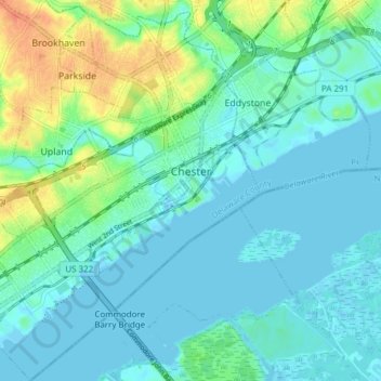
Name: Chester topographic map, elevation, terrain.
Location: Chester, Delaware County, Pennsylvania, 19013, United States (39.81731 -75.40808 39.87584 -75.34209)
Average elevation: 33 ft
Minimum elevation: -7 ft
Maximum elevation: 128 ft
Delaware County trails, hiking, mountain biking, running and outdoor activities
Make a donation
Gear up for your next adventure:
As an Amazon Associate, this site earns from qualifying purchases at no extra cost to you.
Other topographic maps
Click on a map to view its topography, its elevation and its terrain.
Springfield
United States > Pennsylvania > Delaware County > Springfield Township > Springfield
Average elevation: 190 ft
Saint Davids
United States > Pennsylvania > Delaware County > Radnor Township
Average elevation: 400 ft
Make a donation
Gear up for your next adventure:
As an Amazon Associate, this site earns from qualifying purchases at no extra cost to you.
Crum Creek Manor
United States > Pennsylvania > Delaware County > Nether Providence Township
Average elevation: 125 ft
Thornton
United States > Pennsylvania > Delaware County > Thornbury Township
Average elevation: 397 ft
Make a donation
Gear up for your next adventure:
As an Amazon Associate, this site earns from qualifying purchases at no extra cost to you.
Merwood Park
United States > Pennsylvania > Delaware County > Haverford Township > Coreze
Average elevation: 325 ft
Ardmore Park
United States > Pennsylvania > Delaware County > Haverford Township
Average elevation: 312 ft
South Media
United States > Pennsylvania > Delaware County > Nether Providence Township
Average elevation: 213 ft
Dilworthtown
United States > Pennsylvania > Delaware County > Chadds Ford Township
Average elevation: 400 ft
Make a donation
Gear up for your next adventure:
As an Amazon Associate, this site earns from qualifying purchases at no extra cost to you.
Johnsons Corner
United States > Pennsylvania > Delaware County > Concord Township
Average elevation: 381 ft
Pilgrim Gardens
United States > Pennsylvania > Delaware County > Haverford Township
Average elevation: 249 ft
Make a donation
Gear up for your next adventure:
As an Amazon Associate, this site earns from qualifying purchases at no extra cost to you.
Glen Riddle
United States > Pennsylvania > Delaware County > Middletown Township
Average elevation: 226 ft