
Make a donation
Gear up for your next adventure:
As an Amazon Associate, this site earns from qualifying purchases at no extra cost to you.
Alverà topographic map
Click on the map to display elevation.
Make a donation
Gear up for your next adventure:
As an Amazon Associate, this site earns from qualifying purchases at no extra cost to you.
About this map
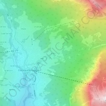
Name: Alverà topographic map, elevation, terrain.
Location: Alverà, Cortina d'Ampezzo, Belluno, Veneto, 32043, Italia (46.52477 12.13082 46.56477 12.17082)
Average elevation: 4,865 ft
Minimum elevation: 3,717 ft
Maximum elevation: 7,572 ft
Make a donation
Gear up for your next adventure:
As an Amazon Associate, this site earns from qualifying purchases at no extra cost to you.
Other topographic maps
Click on a map to view its topography, its elevation and its terrain.
Tofane
Italia > Veneto > Belluno > Cortina d'Ampezzo
Costruita nella seconda metà del XX secolo e divisa in tre tronconi, la funivia Freccia nel Cielo è il più diretto mezzo di trasporto per raggiungere la cima della Tofana di Mezzo. La base (1.250 m s.l.m.), o prima stazione, si trova infatti nel pieno centro di Cortina, proprio davanti al famoso Stadio…
Average elevation: 7,530 ft
Lago del Sorapíss
Italia > Veneto > Belluno > Cortina d'Ampezzo
Il lago di Sorapiss (Lago de Sorapisc in ladino) è un lago naturale posto nel contesto del Gruppo del Sorapiss nelle Dolomiti, in provincia di Belluno, ad un'altitudine di 1925 metri sul livello del mare.
Average elevation: 7,379 ft
Gruppo delle Tofane
Italia > Veneto > Belluno > Cortina d'Ampezzo
Costruita nella seconda metà del XX secolo e divisa in tre tronconi, la funivia Freccia nel Cielo è il più diretto mezzo di trasporto per raggiungere la cima della Tofana di Mezzo. La base (1.250 m s.l.m.), o prima stazione, si trova infatti nel pieno centro di Cortina, proprio davanti al famoso Stadio…
Average elevation: 6,211 ft
Zuel di Sotto
Italia > Veneto > Belluno > Cortina d'Ampezzo
Zuel (Śuel in ladino) è un villaggio nel comune di Cortina d'Ampezzo, in provincia di Belluno. L'altitudine media è di 1.154 m.
Average elevation: 4,009 ft
Make a donation
Gear up for your next adventure:
As an Amazon Associate, this site earns from qualifying purchases at no extra cost to you.