
Make a donation
Gear up for your next adventure:
As an Amazon Associate, this site earns from qualifying purchases at no extra cost to you.
White Mesa topographic map
Click on the map to display elevation.
Make a donation
Gear up for your next adventure:
As an Amazon Associate, this site earns from qualifying purchases at no extra cost to you.
About this map
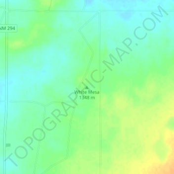
Name: White Mesa topographic map, elevation, terrain.
Location: White Mesa, De Baca County, New Mexico, United States (34.29113 -103.98613 34.29123 -103.98603)
Average elevation: 4,423 ft
Minimum elevation: 4,383 ft
Maximum elevation: 4,478 ft
De Baca County trails, hiking, mountain biking, running and outdoor activities
Make a donation
Gear up for your next adventure:
As an Amazon Associate, this site earns from qualifying purchases at no extra cost to you.
Other topographic maps
Click on a map to view its topography, its elevation and its terrain.
Sumner Lake State Park
United States > New Mexico > De Baca County
The park features a large 4,500-acre (18 km2) reservoir on the Pecos River, created in 1939 by the Sumner Dam of the United States Bureau of Reclamation. The reservoir is home to various fish species including largemouth bass, catfish, crappie and walleye. The park elevation is 4,300 feet (1,300 m) above sea…
Average elevation: 4,301 ft