
Make a donation
Gear up for your next adventure:
As an Amazon Associate, this site earns from qualifying purchases at no extra cost to you.
Siverskyi Donets topographic map
Click on the map to display elevation.
Make a donation
Gear up for your next adventure:
As an Amazon Associate, this site earns from qualifying purchases at no extra cost to you.
Siverskyi Donets
The Donets originates on the Central Russian Upland, near Podolkhi village, Prokhorovka area, north of Belgorod, at an elevation of 200 m (660 ft) above sea level. Its basin contains over 3000 rivers, of which 425 are longer than 10 km (6.2 mi) and 11 are longer than 100 km (62 mi); 1011 of those rivers directly flow into the Donets. These rivers are mostly fed by melting snow, and thus the water supply is uneven during the year. The spring flood lasts about two months, from February to April – during this period the water level rises by 3 to 8 m (9.8 to 26.2 ft). Excessive flooding is rare due to numerous artificial water reservoirs constructed along the river.
Make a donation
Gear up for your next adventure:
As an Amazon Associate, this site earns from qualifying purchases at no extra cost to you.
About this map
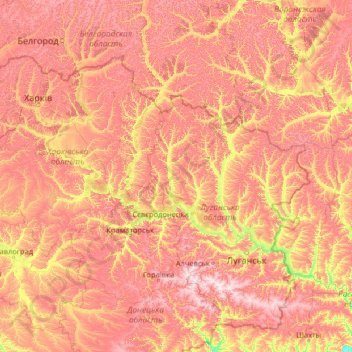
Name: Siverskyi Donets topographic map, elevation, terrain.
Location: Siverskyi Donets, Ukraine (47.59927 36.32748 50.97199 41.07413)
Average elevation: 495 ft
Minimum elevation: 30 ft
Maximum elevation: 1,175 ft
Make a donation
Gear up for your next adventure:
As an Amazon Associate, this site earns from qualifying purchases at no extra cost to you.
Other topographic maps
Click on a map to view its topography, its elevation and its terrain.
Kyiv
Originally on the west bank, today Kyiv is on both sides of the Dnieper, which flows southwards through the city towards the Black Sea. The older and higher western part of the city sits on numerous wooded hills (Kyiv Hills), with ravines and small rivers. Kyiv's geographical relief contributed to its…
Average elevation: 430 ft
Make a donation
Gear up for your next adventure:
As an Amazon Associate, this site earns from qualifying purchases at no extra cost to you.
Dnieper River
The source of the Dnieper is the sedge bogs (Akseninsky Mokh) of the Valdai Hills in central Russia, at an elevation of 220 m (720 ft). For 115 km (71 mi) of its length, it serves as the border between Belarus and Ukraine. Its estuary, or liman, used to be defended by the strong fortress of Ochakiv.
Average elevation: 272 ft
Make a donation
Gear up for your next adventure:
As an Amazon Associate, this site earns from qualifying purchases at no extra cost to you.
Make a donation
Gear up for your next adventure:
As an Amazon Associate, this site earns from qualifying purchases at no extra cost to you.
Make a donation
Gear up for your next adventure:
As an Amazon Associate, this site earns from qualifying purchases at no extra cost to you.
Make a donation
Gear up for your next adventure:
As an Amazon Associate, this site earns from qualifying purchases at no extra cost to you.
Stelmakhivka
The village is located near the border of Luhansk and Kharkiv Oblasts. 20 kilometers from Svatove and 23 kilometers from the urban settlement of Borova. Administratively, the village was arranged into the Svatove Raion in 2020. The elevation is 146 meters.
Average elevation: 554 ft
Make a donation
Gear up for your next adventure:
As an Amazon Associate, this site earns from qualifying purchases at no extra cost to you.
Make a donation
Gear up for your next adventure:
As an Amazon Associate, this site earns from qualifying purchases at no extra cost to you.
Make a donation
Gear up for your next adventure:
As an Amazon Associate, this site earns from qualifying purchases at no extra cost to you.
Make a donation
Gear up for your next adventure:
As an Amazon Associate, this site earns from qualifying purchases at no extra cost to you.
Verkhorichchia
Ukraine > Верхореченское сельское поселение > Verkhorichchia
Average elevation: 1,010 ft
Make a donation
Gear up for your next adventure:
As an Amazon Associate, this site earns from qualifying purchases at no extra cost to you.
Make a donation
Gear up for your next adventure:
As an Amazon Associate, this site earns from qualifying purchases at no extra cost to you.