Geolocate

Berescheid topographic map

Click on the map to display elevation.

About this map

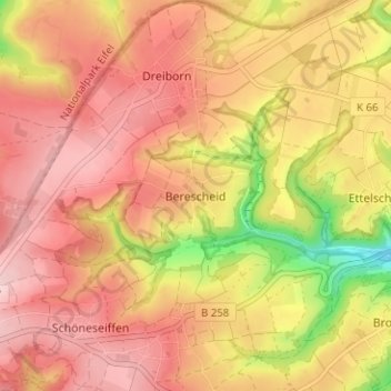
Name: Berescheid topographic map, elevation, terrain.

Location: Berescheid, Schleiden, Kreis Euskirchen, Nordrhein-Westfalen, Deutschland (50.51306 6.39406 50.55306 6.43406)

Average elevation: 1,752 ft

Minimum elevation: 1,335 ft

Maximum elevation: 1,982 ft

Other topographic maps

Click on a map to view its topography, its elevation and its terrain.

Gear up for your next adventure:

🥾Hiking Shoes - Durable and comfortable shoes for trail hiking
🦟Ultrasonic Repellers - Create a bug-free zone at your camp or rest stop
🎒Outdoor Daypacks - Lightweight backpacks designed for carrying maps and essential gear
🪶Compact Camp Shovel - Folding shovel for campsite tasks
🌧️Backpack Rain Cover - Keep gear dry in wet weather

As an Amazon Associate, this site earns from qualifying purchases at no extra cost to you.